
Strengthening Climate Resilience Through Evidence-Based Policy and Planning
December 29, 2025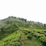
Tourism and landuse change nexus
January 7, 2026
As environmental challenges grow in scale and complexity, decision-makers increasingly rely on data-driven insights. Geographic Information Systems (GIS), remote sensing, and data analytics have become essential tools in environmental and climate governance.
Turning Data into Insight
GIS and remote sensing enable the analysis of land use change, forest cover, climate hazards, biodiversity patterns, and infrastructure risks. When combined with socio-economic data, these tools provide a comprehensive understanding of environmental systems and human interactions.
Supporting Policy and Practice
Spatial data supports evidence-based planning, from identifying climate-vulnerable areas to prioritizing conservation efforts and designing resilient infrastructure. GIS-based analysis also enhances transparency and monitoring, which are critical for donor-funded programs and policy reporting.
Looking Ahead
Investing in geospatial capacity and data analytics strengthens institutions and improves decision-making. As climate and environmental risks continue to evolve, data-driven approaches will remain central to effective, adaptive, and inclusive solutions.